Log in
All resources
Create a design
338 Free Artworks of Maps Of The United States
bibliothèque nationale de france
maps from the earth and its inhabitants, vol. xvii
physical geography (1899) by davis
a map of the british empire in america with the french and spanish settlements adjacent thereto
metropolitan museum of art
everett d. graff collection of western americana
philippe buache
weather maps of the united states
the great south - a record of journeys (1875)
1875 maps of the united states
backs of postcards in curt teich postcard archives
postcards of oklahoma city
historical collections of the state of new jersey (1852)
1852 maps of the united states
maps in the library of congress
old maps of latin america
maps from the earth and its inhabitants, vol. xv
hydrological maps of the united states
maps in the library of congress
1703 maps of the united states
chicago and the midwest, newberry library
great chicago fire of 1871
1805 maps of the united states
maps by john cary
paintings by nakabayashi chikutō in the metropolitan museum of art
19th-century paintings of waterfalls
paintings by nakabayashi chikutō in the metropolitan museum of art
19th-century paintings of waterfalls
surveying in the united states
1854 maps of california
everett d. graff collection of western americana
maps by g. w. & c. b. colton & co.
1750s maps of california
1705 maps of california
the comprehensive history of england (1876)
english-language maps showing history
a map of the british empire in america with the french and spanish settlements adjacent thereto
bibliothèque nationale de france
a map of the british empire in america with the french and spanish settlements adjacent thereto
bibliothèque nationale de france
a map of the british empire in america with the french and spanish settlements adjacent thereto
bibliothèque nationale de france
a map of the british empire in america with the french and spanish settlements adjacent thereto
bibliothèque nationale de france
a map of the british empire in america with the french and spanish settlements adjacent thereto
bibliothèque nationale de france
arnold's geographical handbook (1899)
1899 maps of the united states
arnold's geographical handbook (1899)
1899 maps of the united states
maps from the earth and its inhabitants, vol. xvii
archaeological sites in ohio
1747 maps of new hampshire
english-language maps
glaciers and glaciation (1910)
maps of prince william sound
maps in the library of congress
1777 maps of north america
everett d. graff collection of western americana
st. louis, missouri in the 1800s
scientific journals of the united states, 1902
old maps of lorain county, ohio
bibliothèque nationale de france
maps by tomas lopez
maps by thomas nast
1872 maps of texas
1877 maps of the united states
1870s maps of utah
romanticism
john martin
backs of postcards in curt teich postcard archives
postcards of elk city, oklahoma
french-language maps of north america
1809 maps of north america
battles of lexington and concord
amos doolittle
manners, customs, and condition of the north american indians (1841)
realism
a flying trip to the tropics
old maps of curaçao
maps from the earth and its inhabitants, vol. xvii
1870s maps of the united states
maps from the earth and its inhabitants, vol. xvii
maps of the history of the united states
maps from the earth and its inhabitants, vol. xvii
1870s maps of the united states
maps from the earth and its inhabitants, vol. xvii
topographic maps of the united states
maps from the earth and its inhabitants, vol. xv
first nations people of british columbia
maps from the earth and its inhabitants, vol. xvii
french louisiana
atlas to accompany the official records of the union and confederate armies
everett d. graff collection of western americana
old geological maps by jean-etienne guettard
jean étienne guettard
maps by isaak tirion
old maps of haarlem
romanticism
john martin
a flying trip to the tropics
1895 maps of south america
prints by abraham allard in the rijksmuseum amsterdam
maps in the rijksmuseum amsterdam
nouvelle géographie universelle, vol. xvi
maps of education in the united states
nouvelle géographie universelle, vol. xvi
1876 maps of the united states
maps of essex county, ontario
point pelee national park
everett d. graff collection of western americana
the adventures of captain bonneville
old geological maps by jean-etienne guettard
jean étienne guettard
maps from the earth and its inhabitants, vol. xvii
1870s maps of the united states
physical geography (1899) by davis
allegheny plateau
maps of mountains in the united states
mount shasta
a class-book of modern geography (1898)
old maps of the great lakes
the soldier in our civil war - a pictorial history of the conflict (1893)
1860s maps of the united states
maps from the earth and its inhabitants, vol. xvii
united states geological survey
maps from the earth and its inhabitants, vol. xvii
flora of the united states
maps from the earth and its inhabitants, vol. xvii
coasts of the united states
prints of cartouches in the rijksmuseum amsterdam
maps in the rijksmuseum amsterdam
international astronomical union
map workshop
history of philadelphia
lithographs
maps of paris from the david rumsey historical map collection
1778 in paris
old maps of north holland
maps by isaak tirion
old maps of manhattan, new york city
croton aqueduct
physical geography (1899) by davis
weather maps of the united states
physical geography (1899) by davis
weather maps of the united states
physical geography (1899) by davis
weather maps of the united states
maps of the sierra nevada (united states)
physical geography (1899) by davis
physical geography (1899) by davis
weather maps of the united states
maps by pieter mortier
maps from gallica
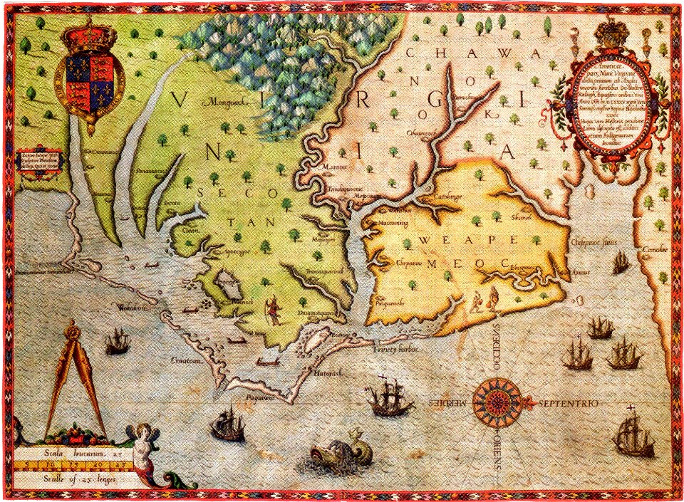
16th-century maps of north carolina
16th-century maps of virginia
west-indische compagnie
image restoration
maps by john cary
1799 maps
david rumsey historical map collection
old maps of the holy roman empire
maps in the stadsarchief amsterdam
daniel stoopendaal
works by constantino brumidi
françois barbé-marbois
the great south - a record of journeys (1875)
1875 maps of the united states
the great south - a record of journeys (1875)
1875 maps of the united states
the great south - a record of journeys (1875)
1875 maps of the united states
maps of roanoke island
theodor de bry
historical royal coats of arms of the netherlands
maps by willem and johannes blaeu
1800s maps of the americas
maps by john cary
a class-book of modern geography (1898)
1898 maps of the united states
stereo cards of the exterior of the united states capitol
neoclassicism
stereo cards of the exterior of the united states capitol
neoclassicism
amos doolittle
ralph earl
1750s maps of california
philippe buache
maps of the caribbean by mercator-hondius
bibliothèque nationale de france
the great south - a record of journeys (1875)
1875 maps of the united states
maps of ports and fortresses of the mediterranean by marco boschini (1651)
bibliothèque nationale de france
maps of ports and fortresses of the mediterranean by marco boschini (1651)
bibliothèque nationale de france
david rumsey historical map collection
1794 maps of the holy roman empire
david rumsey historical map collection
1790s maps of the holy roman empire
prints in the royal collection of the united kingdom
thomas vivares
history of the first regiment minnesota volunteer infantry (1916)
alfred sully
1914 books from the united states
orientalism
a walloon family in america - lockwood de forest and his forbears (1914)
orientalism
the book of birds (1921)
1921 maps
201 - 300 of 338
Next page
/ 4